Gotland, Sweden
The Slow Baltic
Limestone meadows, flat horizons and light that refuses to end.
Why this monthLate Baltic summer holds through September — warm sea, low golden light and an island that has gone quiet again.
Full route, maps & GPX on BicycleMovementOpens the official page in a new tab. Nothing is sold here — how the link works.
- Distance
- 210 km
- Duration
- 4 days
- Ascent
- 900 m
- Country
- Sweden
The seasonLate Baltic summer holds through September — warm sea, low golden light and an island that has gone quiet again. How we read the weather window · the September edition.
The Soul Score is BicycleMovement's official figure for this route, shown here exactly as published on The Slow Baltic route page.
Best time to cycle The Slow Baltic
- Best months
- June – August
- Difficulty
- Gentle
Gotland in high summer is mild, bright and extraordinarily long-lit — the evenings stretch so far north that a day can begin at noon and still finish in daylight. Rain is light and infrequent; wind is the only real weather. The island is at its warmest in August, with the sea warm enough to swim at the end of a day.
We would avoid the dark, wind-driven months from November onward. See the month-by-month weather window for Sweden
How hard is The Slow Baltic?
Flat limestone riding on lanes and firm gravel, with the wind as the only gradient. Distances between villages are short and ferries are frequent, so this is the easiest route in the edition to ride at whatever pace suits.
On the roadFlat limestone island riding on lanes and firm gravel, with the wind as the only real gradient. Distances between villages are short, ferries are frequent, and the long northern evenings let days start late.
Gradients, surface changes and the full elevation profile are published on the official The Slow Baltic page on BicycleMovement, which is the complete version of this journey.
What the route is remembered for
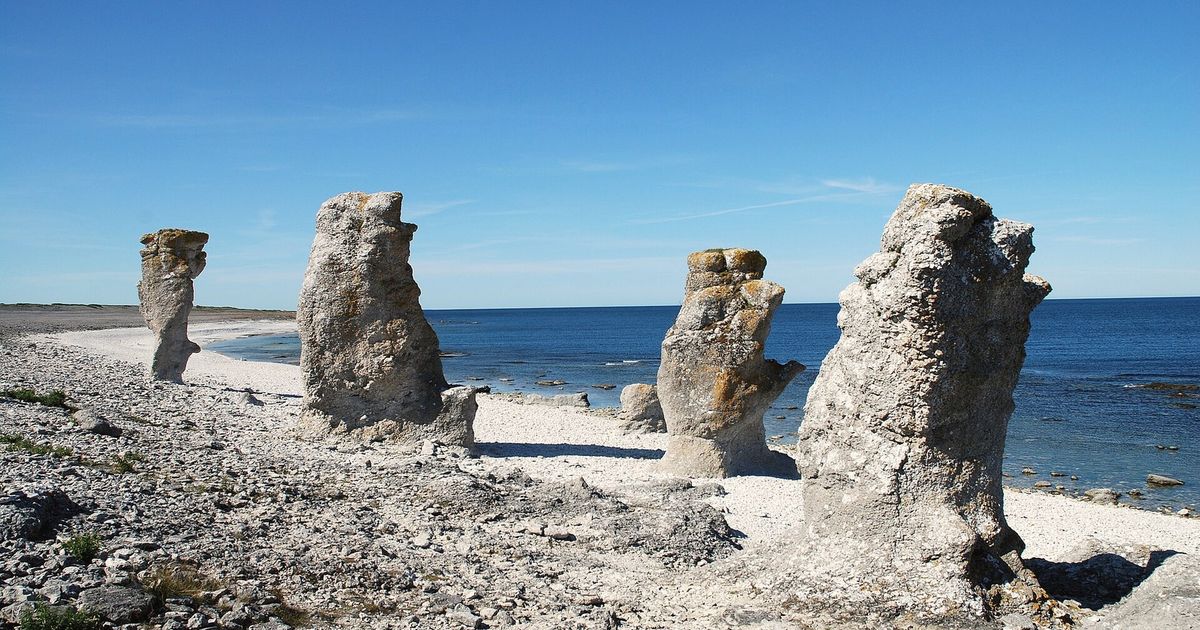
The rauks
Sea stacks standing off the shore like a stone crowd, best seen in the late northern light.
Light that refuses to end
Evenings so long that the day loses its usual shape and the riding stops when you decide it does.
Limestone lanes
Pale, firm and empty, running between stone walls and low pine.
Swimming as part of the route
The Baltic is warm enough in August that most days end in it.
The Slow Baltic cycling itinerary
4 days of riding, 210 km and 900 m of ascent, shaped the way we would ride it — short mornings, long afternoons, and no day that has to be finished.
Days 1–2
East coast
Ferry in, then smooth minor roads north with the Baltic on your right.
Days 3–4
Rauks and gravel
Inland gravel through pine and limestone, coming back to the sea stacks in the evening.
Day 5
Southern tip
Open shore riding, steady wind, and the longest low dusk of the trip.
Day 6
Back to the harbour
An easy return through farmland to the ferry.
The full route
GPX files, offline maps, the elevation profile, day-by-day notes and the planning tools for The Slow Baltic all live on BicycleMovement. We keep only the season and the reason.
Get the GPX + full route on BicycleMovementOpens the official page in a new tab. No signup here, nothing sold here.
The Slow Baltic: common questions
- When is the best time to ride The Slow Baltic?
- June – August. Gotland in high summer is mild, bright and extraordinarily long-lit — the evenings stretch so far north that a day can begin at noon and still finish in daylight. Rain is light and infrequent; wind is the only real weather. The island is at its warmest in August, with the sea warm enough to swim at the end of a day. Month-by-month season guide for Sweden
- How many days does it take?
- 4 days at an unhurried pace — 210 km with 900 m of ascent through Gotland, Sweden. Strong riders shorten it; we would not. The day-by-day breakdown, with distances and overnight options, is on the full The Slow Baltic route page.
- How difficult is The Slow Baltic?
- Gentle. Flat limestone riding on lanes and firm gravel, with the wind as the only gradient. Distances between villages are short and ferries are frequent, so this is the easiest route in the edition to ride at whatever pace suits.
- What are the roads and surfaces like?
- Flat limestone island riding on lanes and firm gravel, with the wind as the only real gradient. Distances between villages are short, ferries are frequent, and the long northern evenings let days start late.
- How do I get to the start?
- Ferries run to Visby from the Swedish mainland and take bikes as a matter of course; the island is small enough that no transfer is long.
- Where do I download the GPX file, maps and elevation profile?
- On the official route page. Get the GPX for The Slow Baltic on BicycleMovement — offline maps, the elevation profile and the planning tools are held there too.
The full route
GPX files, offline maps, the elevation profile, day-by-day notes and the planning tools for The Slow Baltic all live on BicycleMovement. We keep only the season and the reason.
Open the official route pageOpens the official page in a new tab. No signup here, nothing sold here.