Møre og Romsdal, Norway
The Atlantic Road North
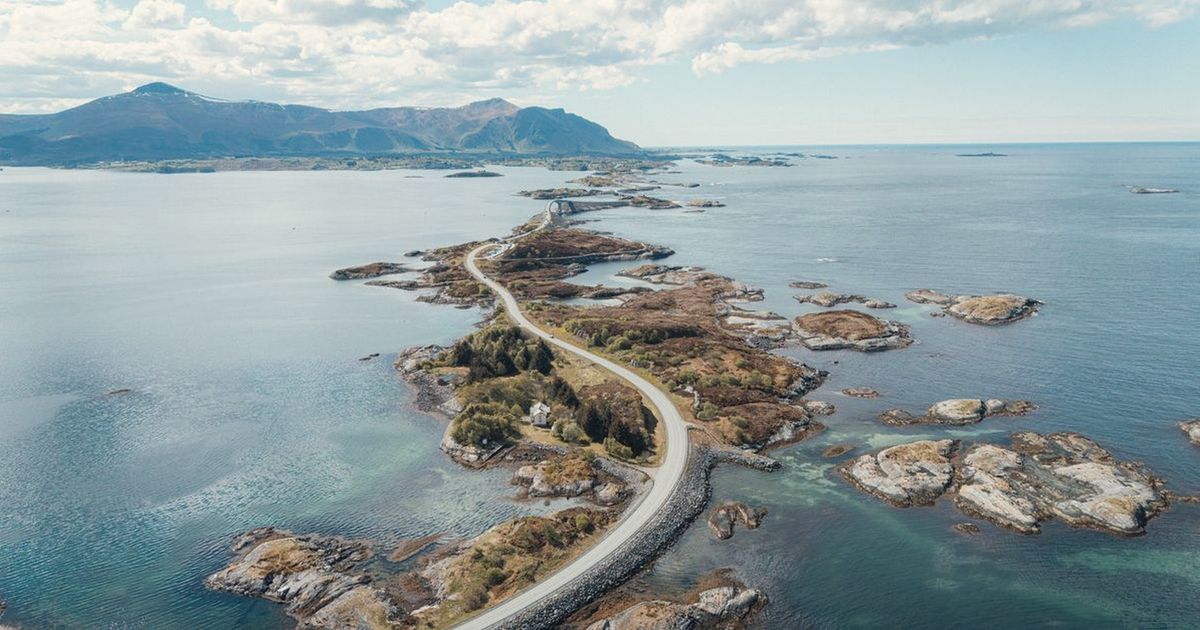
Bare rock, bridges over open water, and weather that changes its mind.
Why this monthAutumn colour arrives on the coast with calm mornings between weather systems and ferries still on summer times.
Full route, maps & GPX on BicycleMovementOpens the official page in a new tab. Nothing is sold here — how the link works.
- Distance
- 260 km
- Duration
- 5 days
- Ascent
- 3,100 m
- Country
- Norway
The seasonAutumn colour arrives on the coast with calm mornings between weather systems and ferries still on summer times. How we read the weather window · the September edition.
The Soul Score is BicycleMovement's official figure for this route, shown here exactly as published on The Atlantic Road North route page.
Best time to cycle The Atlantic Road North
- Best months
- June – August
- Difficulty
- Moderate
The Norwegian coast in high summer is cool, bright and endlessly lit, with the storms that define this shoreline mostly held off until autumn. Rain still arrives — this is the Atlantic — but it comes and goes, and the light between fronts is the reason people come. Wind across the exposed bridges is the thing to plan around, not temperature.
We would avoid the autumn storm season and the dark winter months. See the month-by-month weather window for Norway
How hard is The Atlantic Road North?
Climbing is modest and the surface excellent, but several ferry hops and long exposed causeways shape the days. Crosswind on the bridges is the real difficulty; traffic thins outside the middle of the day.
On the roadCoastal road and island causeways with modest climbing and several ferry hops built into the route. Traffic thins outside midday; sheltered stretches alternate with fully exposed bridges where the crosswind is felt.
Gradients, surface changes and the full elevation profile are published on the official The Atlantic Road North page on BicycleMovement, which is the complete version of this journey.
What the route is remembered for
Causeways over open water
Bridges that arc between islands with nothing but sea on either side — exposed, exhilarating, brief.
Light that never quite goes
Northern summer nights that stay pale enough to ride through if you want to.
Ferries built into the route
Short crossings that break the day and give the legs a rest whether they need it or not.
Fishing villages on stilts
Red timber, drying racks and harbours where the working day starts long before yours.
The Atlantic Road North cycling itinerary
5 days of riding, 260 km and 3,100 m of ascent, shaped the way we would ride it — short mornings, long afternoons, and no day that has to be finished.
Days 1–2
Fjord edge
Sheltered water-level roads with short ferry hops between them.
Days 3–4
Causeways
The exposed section — bridges, skerries and crosswind, best ridden in the morning calm.
Day 5
Island detour
A quiet day off the main line among fishing villages.
Days 6–7
North
Two final coastal days, with autumn colour arriving in late August.
The full route
GPX files, offline maps, the elevation profile, day-by-day notes and the planning tools for The Atlantic Road North all live on BicycleMovement. We keep only the season and the reason.
Get the GPX + full route on BicycleMovementOpens the official page in a new tab. No signup here, nothing sold here.
The Atlantic Road North: common questions
- When is the best time to ride The Atlantic Road North?
- June – August. The Norwegian coast in high summer is cool, bright and endlessly lit, with the storms that define this shoreline mostly held off until autumn. Rain still arrives — this is the Atlantic — but it comes and goes, and the light between fronts is the reason people come. Wind across the exposed bridges is the thing to plan around, not temperature. Month-by-month season guide for Norway
- How many days does it take?
- 5 days at an unhurried pace — 260 km with 3,100 m of ascent through Møre og Romsdal, Norway. Strong riders shorten it; we would not. The day-by-day breakdown, with distances and overnight options, is on the full The Atlantic Road North route page.
- How difficult is The Atlantic Road North?
- Moderate. Climbing is modest and the surface excellent, but several ferry hops and long exposed causeways shape the days. Crosswind on the bridges is the real difficulty; traffic thins outside the middle of the day.
- What are the roads and surfaces like?
- Coastal road and island causeways with modest climbing and several ferry hops built into the route. Traffic thins outside midday; sheltered stretches alternate with fully exposed bridges where the crosswind is felt.
- How do I get to the start?
- Molde and Kristiansund airports bracket the route, and coastal buses carry bikes between them.
- Where do I download the GPX file, maps and elevation profile?
- On the official route page. Get the GPX for The Atlantic Road North on BicycleMovement — offline maps, the elevation profile and the planning tools are held there too.
The full route
GPX files, offline maps, the elevation profile, day-by-day notes and the planning tools for The Atlantic Road North all live on BicycleMovement. We keep only the season and the reason.
Open the official route pageOpens the official page in a new tab. No signup here, nothing sold here.